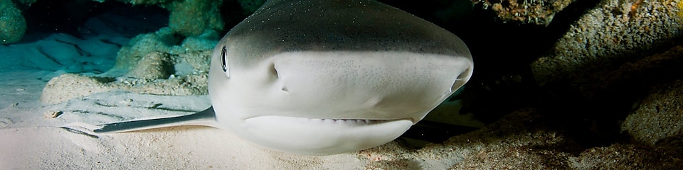
ชีวิตใต้ผืนน้ำ
ความหลากหลายทางชีวภาพใต้มหาสมุทรนั้นกำลังตกอยู่ในความเสี่ยงจากการทำประมงที่มากเกินไป มลภาวะ การเปลี่ยนแปลงสภาพทางภูมิอากาศ และปัจจัยอื่น ๆ เราทำงานร่วมกับรัฐบาล องค์กรเอกชน และผู้เชี่ยวชาญท่านอื่น ๆ เพื่อเสาะหาวิธีปกป้องความหลากหลายทางชีวภาพทางทะเลของโลกใบนี้
เราสนับสนุนโครงการวิจัยต่าง ๆ เพื่อเพิ่มความเข้าใจเกี่ยวกับสัตว์ทะเลเลี้ยงลูกด้วยนมและพฤติกรรมของพวกมัน เพื่อหาวิธีหลีกเลี่ยงการรบกวนขณะที่เราดำเนินงานในสิ่งแวดล้อมใต้ทะเล เชลล์เป็นสมาชิกของ the International Association of Oil and Gas Producers (IOGP) Joint Industry Programme on Sound and Marine Life ซึ่งเป็นแนวคิดเพื่อเสริมสร้างความเข้าใจผลกระทบด้านเสียงที่เกิดจากการขุดหาน้ำมันและก๊าซรวมถึงการดำเนินการต่าง ๆ ที่ส่งผลต่อชีวิตสัตว์ทะเล
อ่านเพิ่มเติมเกี่ยวกับตัวอย่างของการดำเนินงานของเราในการปกป้องชีวิตใต้ผืนน้ำ
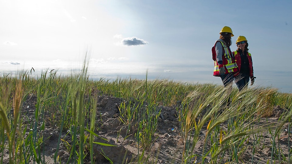
การร่วมมือกับชุมชนต่าง ๆ ในประเทศฟิลิปปินส์
ในประเทศฟิลิปปินส์ เรากำลังช่วยชุมชนท้องถิ่นต่าง ๆ ในการอนุรักษ์สิ่งแวดล้อมทางทะเลบางส่วนที่มีความอุดมสมบูรณ์ทางความหลากหลายทางชีวภาพแห่งหนึ่งของโลก หรือที่เรียกว่า “สามเหลี่ยมปะการัง” (Coral Triangle) แรกเริ่มเดิมที ชาวบ้านที่อาศัยอยู่บริเวณริมชายฝั่งใช้ชีวิตพึ่งพาการทำประมงเพื่อการดำรงชีวิต อย่างไรก็ตาม การทำประมงที่มากเกินไปทำให้ฝูงปลาเริ่มลดจำนวนลงในขณะที่วิธีการทำประมงอย่างผิดกฎหมายที่ใช้ไดนาไมต์หรือไซยาไนด์ ได้สร้างภัยคุกคามที่ยิ่งใหญ่ที่สุดต่อเหล่าปะการัง โครงการที่ได้รับเงินสนับสนุนจากเชลล์ผ่านมูลนิธิมาลัมปายา (Malampaya Foundation)ได้ช่วยให้ชาวประมงหลายพันชีวิตได้มีรายได้จากแหล่งอื่น พร้อมกับช่วยให้มีปริมาณปลาจำนวนมากขึ้น และสนับสนุนความพยายามอนุรักษ์ปะการัง


Watch: Conserving the Coral Triangle
INTV:
After graduating from high school, I started doing compressor fishing because that is the primary livelihood here in Bulalacao. The use of compressor, dynamite, cyanide and more.
In 2007, they banned compressor fishing .
VO:
The Philippines is a group of 7000 islands lying in the Coral Triangle.
These waters support more species than any other marine environment on the planet.
And many fishing villages rely on them for their survival.
But this richly biodiverse area faces many threats.
And so, a solution needed to be found.
Title: Conserving the Coral Triangle
VO:
The Malampaya deep-water gas-to-power platform lies off the coast of Palawan island and supplies up to 20% of electricity in the Philippines.
INTV:
This area is really pristine and for Shell it is important for us to keep it that way.
VO:
A big promise to live up to.
Shell committed to protect the area by building its pipeline around the reefs and other sensitive areas
But there are other challenges in the area – such as threats to marine life from illegal fishing techniques and over-fishing.
INTV:
Majority of our assets for Malampaya are actually marine-based and so the primary communities are really coastal communities.
VO:
The Malampaya foundation, set up by Shell and its Joint Venture partners, helps communities establish marine protected areas. And partners with communities to "organize" reef watch teams.
INTV:
Conservation is the most fulfilling job that a marine biologist can get. Helping those communities protect and conserve the marine environment is really an opportunity for us
VO:
Jun - is one of the local fishermen who is now part of a community reef team.
INTV:
Corals are dying. Even the fish are decreasing in number. That’s why I changed my occupation.
INTV:
We train them in scuba diving and then after that we train them to monitor the reefs, so they're licensed scuba divers and they're also licensed reef checkers
VO:
To help rehabilitate blasted reefs, rescued coral fragments are given a better chance to survive when they are moved to elevated nursery beds.
There are 19 coral nurseries with reef watch teams monitoring their health every month.
INTV:
We're just trying to rescue those coral fragments, put it on a nursery bed and then allow it to grow.
The ultimate goal is to help out communities rebuild and restore the marine environment.
INTV:
My main role is monitoring the fish population – if it increases or decreases. The population increased not just in terms of number but also in terms of variety.
INTV:
We've been doing monitoring since 2012, in 3 years we're seeing improvements in the fish population. That's an indication that their conservation programme in the area is working.
VO:
But reef monitoring and coral rehabilitation are just part of the solution.
For marine conservation to be truly sustainable, Malampaya Foundation works at the grassroots level with communities and local governments to implement a comprehensive coastal resource management programme that involves education, advocacy and planning with the people to reduce threats, improve management and help enforce laws.
INTV:
The benefits of marine conservation programmes aren't immediate but we educate them on sustainable development. If they conserve it now, they can get what they need for today and also have something left for tomorrow and for the next generations.
VO:
Elsewhere in Bulalacao, training programmes are helping communities to find alternative livelihood opportunities
INTV:
Malampaya has been really helpful to a lot of people. They provided training in sewing and hog raising.
INTV:
I am happy. The training has been a great help for us – it's fun and educational. This is a way for the women and housewives in our village to contribute to our families.
VO:
Local people have been raising pigs using traditional methods for decades but the Malampaya Foundation advised on more organic and hygienic ways of feeding them.
INTV:
I am so thankful to be involved in this hog raising project. It's really helpful to us because my husband is only a fisherman who earns very little. I have four kids that I need to send to school. This has been a huge help.
INTV:
I told myself that I made the right decision in changing my job and joining this team. It's an opportunity for my wife and I to provide a better life for our kid. I don't want my kid to struggle like I did. I want him to experience a better future, one that I didn't have.
VO:
In this idyllic setting – with the support of the Malampaya Foundation, local people like Jun are helping to bring long-lasting benefits to their environment and creating sustainable sources of livelihood, now and for future generations
Shell's Cougar Platform Becomes an Artificial Reef
Title: Shell’s Cougar Platform Becomes and Artificial Reef
Duration: 2:17
Description:
The story of how Shell’s Cougar platform is now helping support a vibrant marine ecosystem in the Gulf of Mexico
In this film we see the people who helped turn Shell’s Cougar platform into an artificial reef.
Transcript
[Background music plays]
Thoughtful, peaceful, and positive music plays
[Calm, blue open-water in the Gulf of Mexico]
The Gulf of Mexico, six hundred thousand square miles of blue waters as far as the eye can see.
[Remote operated vehicle (ROV) camera showing underwater scenes in the Gulf of Mexico]
But the base and floor can be an inhospitable host to marine life
[Mike McDonough Louisiana Department of Fish and Wildlife]
Specifically in the Gulf of Mexico and especially off Louisiana we are a heavy mud bottom. There’s not a lot of hard structure out there.
[Animation showing the location of Shell’s cougar platform and marine life swimming along an artificial reef]
That’s changing. 90 miles from the Louisiana coast. The bottom of the Gulf of Mexico is a vibrant, diverse and thriving marine ecosystem.
[Mike McDonough Louisiana Department of Fish and Wildlife]
These platforms are attracting fish in these huge numbers. A reefed platform kind of becomes like an underwater city.
[Shell’s cougar platform in the Gulf of Mexico]
Cougar, once one of Shell’s most prolific oil platforms, will now be a new marine metropolis.
[Donal Rajasingam, Asset Manager for Shell & fish swimming in an artificial reef]
Cougar’s future, it’s going to be the home for a pretty large and diverse amount of fish and sea life. We took the St301 platform and jacket and turned it into an artificial reef.
[Remote operated vehicle (ROV) cutting parts of the platform underwater and graphic of removing a platform’s jacket]
Shell is donating the steel frame – or jacket – to the Louisiana Artificial Reef program.
[Tracey Burger and taking apart the Cougar platform]
It’s not reverse engineering by any stretch of the imagination. It’s poetry in motion. They slide completely over the platform and then they lift it and then they slide over the barge and they sit it down. They have to lift it up 20, 30, 40 feet so it’s free to be towed to the reefing area.
[Cougar platform]
Shell’s cougar platform helped define the outer limits of the Gulf of Mexico. A steel monument to human ingenuity and innovation that pioneered a new wave of offshore oil and gas development.
[Donal Rajasingam and marine life swimming in an artificial reef]
Not only do we put out heart and soul into building, producing and operating these facilities...the fact that Cougar has become a part of the ecosystem that we call home is really something for us to be proud of.
[Tracey Burger and underwater cutting and de-construction of the Cougar platform]
Cougar to me is like an old friend that has been very productive and is getting ready to retire. And its time for them to go onto greener pastures.
[Marine life swimming in an artificial reef and text overlay]
Shell made a $619,000 Donation to the Louisiana Department of Wildlife and Fisheries to help maintain and support the reef for years to come.
To learn more visit www.shell.us/sustainability/conservation
Watch: How deep sea data is helping us to learn more about the Gulf of Mexico
Title: Secrets of the Deep: The Stones Metocean Monitoring Project
Duration: 3:55 minutes
Description:
An introduction to the Metocean Monitoring Project. In the Gulf of Mexico sits Shell’s Stones oil and gas field. An ocean weather station floats in the Stones, anchored by a three-kilometer mooring lined dotted with instruments that collect marine data and monitors weather and sea conditions in order to understand the Gulf of Mexico’s role in global climate and ocean circulation.
Through partnerships, Shell has opened up parts of the line to universities and research institutions. Scientists and university researchers are now able to collect data at unprecedented depths using their own instruments and new technologies when the line is hauled in for maintenance.
Secrets of the Deep: The Stones Metocean Monitoring Project Transcript
[Background music plays]
Rhythmic music featuring synthesised effects
[Video footage]
Aerial view panning across the open water of the Gulf of Mexico. Text appearing centre-screen as displayed below.
[Text displays]
In a remote part of the Gulf of Mexico, USA is the world’s deepest oil & gas development, known as “Stones”.
[Video footage]
View of Shell scientists and university researchers on a research vessel using ropes and pulleys to lift up an ocean weather station. Side-angled view of the men lowering the weather station into the ocean as one man manages the ropes attached to the anchors. Text appears on-screen as displayed below.
[Text displays]
Summer 2017: Shell scientists and university researchers seized the unique opportunity to collect data at unprecedented depths.
[Video footage]
View of a Shell researcher standing on the deck of a research vessel. In the distance, the ocean weather station floats on the water surface. Closer shot of the weather station on the ocean surface. Text appears on-screen as displayed below.
[Text displays]
Together they set oceanographic weather and ecosystem monitoring instruments on a buoy and mooring line anchored to the ocean floor.
[Animation]
Map showing location of the Stones field south of New Orleans in the Gulf of Mexico. The state of New Orleans is highlighted in yellow. Zoom in as text appears as displayed below.
[Text displays]
200 miles south of New Orleans in the Gulf of Mexico
[Animation]
Animation of the Stones monitoring station on the sea surface. To its right, the Turritella, an FPSO facility. Descending down from the monitoring station below the surface is the mooring line which is dotted with monitoring equipment and anchored to the seabed at 3,000 metres depth. To the left, the metres depth illustrated. Text appears on-screen as displayed below.
[Text displays]
The Stones monitoring station anchored to the seabed by a mooring line
[Video footage]
View of scientists walking on the deck of a research vessel. Several underwater gliders sit on the deck. View of Shell personnel hauling the anchors into place on the deck and connecting them to large chains. Shot taken from the vessel as a pulley lowers the anchors into the ocean with the buoys floating on the sea surface. Text appears on-screen as displayed below.
[Text displays]
The mission: understand the Gulf of Mexico’s role in global climate and ocean circulation.
[Voice heard over radio]
Three, two, one, go, go, go.
[Video footage]
A Shell worker releases the cable holding the anchors as they are dropped into the ocean.
Interview with Ruth Perry
[Text displays]
Ruth Perry
Shell Marine Scientist and Regulatory Policy Specialist
[Title]
Shell Marine Scientist and Regulatory Policy Specialist
Ruth Perry
The Gulf of Mexico has always had this large role. It has a potential role in understanding climate.
[Video footage]
Close-up of Ruth Perry speaking to off-screen interviewer set against an out-of-focus background.
Interview with Steven DiMarco
[Text displays]
Steven DiMarco
Texas A&M University
Professor of Oceanography
[Title]
Professor of Oceanography
Steven DiMarco
More than 15 million people live around that rim of the Gulf of Mexico, so it’s important societally and economically and it’s important globally.
[Video footage]
Close-up of Steven DiMarco speaking to off-screen interviewer set against an out-of-focus background of floor-to-ceiling screens showing weather patterns and other oceanographic data. Aerial view panning across coastal homes towards the beach. Back to close-up of Steven.
Ruth Perry
Year to year we have hurricanes and tropical storms. The Gulf of Mexico is a large marine ecosystem and it’s a large environment.
[Video footage]
View of a ship at sea being battered by high waves. Satellite image of a hurricane/tropical storm. Back to close-up of Ruth. View of open water with calm waves.
Interview with Christopher Hayes
[Text displays]
Christopher Hayes
University of Southern Mississippi
Assistant Professor of Marine Science
[Title]
Assistant Professor of Marine Science
Christopher Hayes
It’s a very dynamic ocean. The Loop Current comes through there so that’s this very strong current that becomes the Gulf Stream and that’s just happening at the surface.
[Video footage]
Close-up of Christopher Hayes speaking to off-screen interviewer set against an out-of-focus background in a laboratory. View of open water. Zoom in on a computer screen showing a weather map and the current in the Gulf.
Ruth Perry
How do we look at what’s going on down there, and how does that affect all of these natural and man-made phenomenon? And so that’s kind of where the Stones opportunity came from.
[Video footage]
Zoomed-in view panning down a whiteboard with some out-of-focus text written across it. Back to close-up of Ruth. Zoomed-in shot of bubbles rising up from below the sea surface.
Interview with Pak Leung
[Text displays]
Pak Leung
Shell Metocean Specialist
[Title]
Shell Metocean Specialist
Pak Leung
How can we utilise that data for wider community instead of just oil and gas, or just Shell?
[Video footage]
Close-up of Pak Leung speaking to off-screen interviewer set against an out-of-focus background. View of Matthew Howard standing up and teaching to a class of students. Behind him, a table with data is projected onto a screen as he gesticulates. Close-up of several students in Matthew’s class.
Interview with Matthew Howard
[Text displays]
Matthew Howard
Texas A&M University
GCOOS Data Management Coordinator
[Title]
GCOOS Data Management Coordinator
Matthew Howard
They’re opening it up to researchers to put their own equipment on it.
[Video footage]
Close-up of Matthew Howard speaking to off-screen interviewer set against an out-of-focus background. Aerial shot of two shipping vessels at sea side-by-side. The larger vessel to the left has a helipad.
Ruth Perry
We can bring folks with us, our partners like the University of Southern Mississippi and Texas A&M, and people can do some oceanographic work while we’re doing the servicing of the mooring.
[Video footage]
View of a man walking towards the entrance of a building. At the top of the building is written The University of Southern Mississippi Oceanographic Support Facility. View of a different building with many trees planted in front of it and a flagpole flying the American flag and a Texan flag.
To the right of the shot in front of the building on a lawn sits a stone wall with lettering reading GERG, Geochemical & Environmental Research Group, College of Geosciences, Texas A&M University, 833 Graham Road, College Station. Shot of several scientists on the deck of a shipping vessel. Two scientists are holding long poles over the water.
Close-up of a scientist holding and shaking a small flask. In front of him, a table with equipment on the deck of a research vessel.
Steven DiMarco
I’m really excited that Shell would move forward with such a visionary idea.
[Video footage]
Shot of Steven talking to several students at an exterior location as a dark silhouette passes in front of the shot. Back to close-up of Steven. Zoomed-in view panning upwards of graphs illustrating temperature and salinity in the East and West Mission.
Matthew Howard
The prospects of getting real-time data back from the deep Gulf, we’re pretty excited by that.
[Video footage]
Back to close-up of Matthew.
Steven DiMarco
So I teach a lot of the data methods classes in the department of oceanography. I work in the ocean and I bring that information right to the student, right inside the classrooms. They like to see the context, they like to see the data. It’s that proof that leads to better understanding.
[Video footage]
Out-of-focus shot of Steven holding a water bottle walking through a doorway into a building. The shot then comes into focus as several students follow Steven into the building. Close-up of a Slocum Electric Glider. In the background, Steven and his students can be seen out-of-focus. Side-angled view of Steven explaining something to a group of students. Back to close-up of Steven. Back to the shot of Steven explaining to his students. Close-up of one of the female students. Wide-angled view of Steven and his students standing by two very large tank-like pieces of equipment.
Christopher Hayes
So I’m interested in measuring how much CO2 is in the water near the mooring because we know CO2 is changing in the atmosphere, but how those changes translate to changes in the ocean could be really important for how things might change in the future.
[Video footage]
View of Christopher at work in a laboratory. Close-up of Christopher’s gloved hands holding a large syringe which he then subsequently inserts into a piece of monitoring equipment. Various close-ups of measuring equipment. Back to close-up of Christopher.
Ruth Perry
It’s also getting clued on autonomous technologies as well, things like underwater gliders.
[Video footage]
Back to close-up of Ruth. Close-up of the small yellow fin of an underwater glider descending down into a pool of water. View of researchers lowering an underwater glider down some steps on the deck of a research vessel, while one researcher takes pictures.
Interview with Kevin Martin
[Title]
Senior Marine Instrumentation Specialist
Kevin Martin
This is an autonomous vehicle. Go out on the research vessel, put this in the water fully unattended 365 days out of the year, either using the mooring as a centre line or endpoint, and then we can work on extracting out a 3D to 4D image of what’s going on out in the Gulf in that area.
[Video footage]
View of Kevin Martin with an underwater glider on a table in front of him explaining to off-screen interviewer. Shot of researchers lowering a glider into the ocean. Shot taken from a camera onboard a glider as it drops into the water forming bubbles. Underwater shot of a glider. Close-up of Kevin speaking to off-screen interviewer. Close-up of a computer screen showing a 3D model, an out-of-focus person sat at the computer. Zoomed-in view of the 3D model spinning around. Close-up of a table containing weather map data.
Pak Leung
We need to collect that data. We need to understand what is going on down there.
[Video footage]
Out-of-focus face seen looking at a weather map. Close-up shot of a graph illustrating salinity levels. Back to close-up of Kevin.
[Text displays]
Kevin Martin
University of Southern Mississippi
Senior Marine Instrumentation Specialist
Kevin Martin
And that affects both industry, private lives, the fishing industry, oil industry. Everybody in the Gulf of Mexico is affected by what’s going on in the Gulf of Mexico as a whole, not just in the coastal environment but also in the deep Gulf.
[Video footage]
View of researchers preparing some equipment on the deck of a research vessel. Close-up of said equipment being lowered into the ocean. Underwater shot of said equipment.
Pak Leung
Whatever instrument we put on there, that will be a long-term time series measurement. We are talking about decades.
[Video footage]
Back to close-up of Pak. View of an underwater glider just beneath the sea surface attached to a small buoy. In the lower right-hand corner of the shot, part of the research vessel and a researcher look on.
Kevin Martin
Having a long-term mooring at 3,000 metres in any body of water is a scientist’s dream.
[Video footage]
Underwater shot of a glider. Close-up of bubbles being formed underwater as the glider descends. Back to close-up of Kevin. Exterior shot of a floating monitoring station, anchors, large chains and other bits of equipment sat in a yard.
Ruth Perry
And we can use that as a model to build potentially more of these systems, and so then we keep adding to that and we keep building our knowledge. It’s that public private partnership, you know, that we’re going to build for the next two decades and more, and then bringing that data to life, developing it into something that really connects people to the deep sea.
[Video footage]
Close-up of small solar panel affixed to a piece of equipment. View of a researcher sat working on a floating monitoring station with several solar panels inside a building. Shot of Steven explaining to a group of students standing by a large water tank with a glider inside it. Close-up of a man working on a bit of electrical equipment.
Back to close-up of Ruth. View of the open water, the side of a research vessel to the right of the shot, then disappearing from view as the shot pans left. Text appears on-screen as displayed below against an out-of-focus background of moving, glistening particles.
[Text displays]
The Metocean Monitoring Project is a long-term study expected to span decades. Shell is committed to the invaluable data collection for the lifetime of the Stones Project.
[Audio]
Shell jingle
[Graphic]
Shell Pecten centred on a white background
จากแท่นขุดเจาะสู่ปะการัง
หลังจากได้ผลิตน้ำมันอย่างปลอดภัยเป็นจำนวนมากกว่า 31 ล้านบาร์เรล ในช่วงเวลาเกือบ 2 ทศวรรษ ในปัจจุบัน Cougar แพลตฟอร์มของเชลล์ ได้ช่วยให้เกิดระบบนิเวศที่อุดมสมบูรณ์และมีชีวิตชีวาในบริเวณอ่าวเม็กซิโกด้วยการใช้ปะการังเทียม เชลล์บริจากโครงเหล็กที่จะช่วยค้ำยันชั้นของ Cougar และบริเวณด้านบน (หรือที่เรียกว่า แจ็กเก็ต) ให้กับโครงการปะการังเทียมในรัฐหลุยเซียน่า เพื่อมอบต่อให้กับแผนกสัตว์ป่าและการประมงแห่งรัฐหลุยเซียน่า เพื่อรักษาและสังเกตการณ์แนวปะการัง ตอนนี้แจ็กเก็ตได้กลายเป็นแหล่งที่อยู่อาศัยของสัตว์ทะเลหลากหลายชนิดรวมถึง ปลากะพงแดง ปลาหางเหลือง และปลาจำนวนมากที่พึ่งพาแนวปะการังใต้ทะเล
ดูรายละเอียดเพิ่มเติมในความยั่งยืน
ความหลากหลายทางชีวภาพ
โครงการต่าง ๆ ของเราสามารถส่งผลกระทบต่อพื้นที่อยู่อาศัยตามธรรมชาติที่ซึ่งชุมชนต่างพึ่งพาสิ่งเหล่านี้เช่นกัน
เรียนรู้เพิ่มเติมเกี่ยวกับงานของเราในด้านความหลากหลายทางชีวภาพรอบโลก
การเปลี่ยนแปลงของสภาพภูมิอากาศและการเปลี่ยนผ่านด้านพลังงาน
หน้าที่หลักสำหรับสังคมและสำหรับเชลล์คือการหาวิธีการผลิตพลังงานที่ปล่อยก๊าซคาร์บอนไดออกไซด์ในปริมาณต่ำ